
Welcome
I really started The Outdoor Gems to share outdoor experiences through photography and storytelling to inspire more people to get outside. If more people got outdoors; took a walk, hike, went snowboarding, sat around a campfire, and surfed in the ocean, I think the world would be a better place.
-Jeremiah
The Latest

Sedona Arizona, Everything you should know about hiking the Soldiers Pass Trail
Looking to take a desert trip? Sedona in Arizona is one of the more inspiring outdoor places I have ventured to with lots of different
Disclosure: When you buy something through the Affiliate product links I have created below, I earn a small commission. I only promote products and companies I support as well as believe in.
Looking to take a desert trip? Sedona in Arizona is one of the more inspiring outdoor places I have ventured to with lots of different hiking trails, red rock formations, canyon walls, vortexes, endless views that overlook the desert/mountain landscape, and cool hidden gems such as the Soldiers Cave in this hike.
Out of all the hikes I did in my four day trip in Sedona, Soldiers Pass was my favorite. I loved the variety of scenery, the elevation gain to the cave, and the different stops along the hike (Seven Sacred Pools/Devils Sinkhole). What’s great is this hike is also walkable from town (we missed the last shuttle), keep reading for info on parking and the shuttle.
In this post I’ll be going over how to get to Sedona, where to park, best time to visit, what to expect, trail information, and what to pack for a hike in the desert. Alright, lets goooo

Where is Sedona
Sedona is a city (more like a big town) in the northern part of Arizona close to an hour south of Flagstaff and two hours north of Phoenix. It’s part of the Coconino National Forest and is a great place to visit if you love the outdoors or scenic views. While hanging out in Sedona you’ll find people who enjoy hiking, biking, photography, or just relaxing.
Sitting at 4,350 feet/1326 meters, Sedona is considered the high desert and even gets snow in the winter time! Although Sedona isn’t a national park there are two state parks; Red Rock State Park and Slide Rock State park. As you drive into town you’ll notice canyons, mesas (a mountain with a wide flat top), buttes (Tall tower looking mountains), and rock formations all with a reddish color hence the nickname Red Rock Country.

How do I get to the Trailhead
Trailhead Coordinates: 34.88420, -111.78377
Please note that if you are going to hike for more then 3 days, you should purchase a Red Rocks Weekly Pass to be displayed on a your car dash. As mentioned even though Sedona isn’t a National Park, a National Parks pass will work as well. A daily pass at trailheads is $5, a weekly pass is $15, and an annual pass is $20. These passes can be purchased through recreation.gov. *A pass isn’t needed for the Soldiers Pass trailhead but will be required for many other trails in Sedona.*
To drive to the trailhead you’ll head west out of town onto Soldiers Pass Road. Take a right onto Shadow Rock Drive and then a left onto the Forest Service Road. On the right you will see the parking lot. One thing to note is the trailhead is gated and open from 8am-6pm. So make sure to get back to the parking lot from the trail before 6! or your car will be stuck for the night. If you’re looking to do a sunset or sunrise hike, park in the lots described below or extend your hike on trail by parking at the Jordan Road Trailhead.
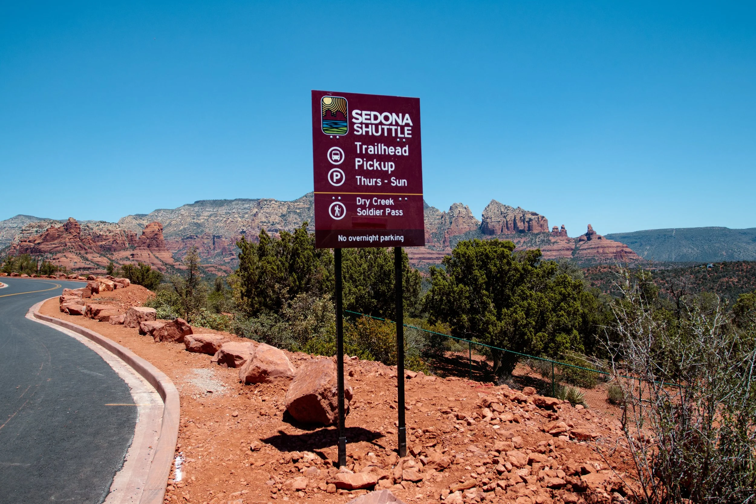
The first thing to note about the Trailhead of Soldiers pass is there is only 14 parking spots and it is in a neighborhood. I would plan on getting there as early as possible if you want to Park at the trailhead. If trailhead is full, you can park about a mile away, close to the West Sedona Elementary School. There’s a parking lot (Posse Grounds) and also some street parking near the school. Do not park in the neighborhood to Soldiers Pass as your car will get ticketed and towed.
Also note that Thursday-Sunday you cannot park at the trailhead, you will have to park at the Posse Grounds Park and Ride and take a free Shuttle to the trailhead. You can find pickup time information at Sedonashuttle.com. If parking is full in the shuttle lot there is some street parking near the Elementary School. The last shuttle picks up at 5:51 pm, so don’t miss it or you’ll be walking back to your car like we did. The walk is about a mile if you miss the last shuttle.

Is Soldiers Pass a difficult Trail
I would rate the hike as moderate with some elevation gain towards the end as you approach the Cave. Depending on your speed the hike can take anywhere from 2-4 hours. Below I’ve listed some trail stats. Also, a really helpful app I use a lot when hiking is All trails. Perfect for navigating a hike, looking at trail reviews, and getting trail information.
Distance- 4.5 miles/7.25 km
Elevation Gain- 839 feet/256 meters
Dogs- Must be on leash
Best time of the day to hike- Early Morning or Late afternoon
Trail Type- Loop

How to get to the Soldiers Pass Cave and what is the Trail Like
Alright, so you made it to the trailhead and you’re looking to hike all the way to the cave. One thing to note about Sedona is a lot of trails connect or lead to other trails in the area. The visitor center in Downtown Sedona will have maps and also knowledgeable staff to give you more information on connecting trails in the area. If you decide not to hike to the Cave, you can stay left on the Soldiers Pass trail and it will take you all the way to the Brins Mesa Trail.
As you start hiking, within the first five minutes you’ll come across the Devils Kitchen, a giant sinkhole cause from red wall limestone gradually eroding and collapsing overtime. There are other sinkholes in the Sedona area with this one being one of the most popular ones. It’s most recent collapse was in 1995 and the hole itself is 50 feet deep and 150 by 90 feet in size.
You might also notice a wider path as you’re hiking the Soldiers Pass trail. This is for jeep tours that are offered on certain trails in Sedona, if you don’t want to hike.


As you continue hiking, the next cool site on the trail will be the Seven Sacred Pools. A series of small pools of water that were naturally carved out of the sandstone and once considered sacred by Native America Tribes. There’s a chance they could be dried up if you hike this trail during warmer months, but still really cool to look at. Probably one of my favorite views on the hike with the desert mountains in the background. The group of mountains you see off in the distance are called Coffee Pot Rock.
If you’re looking to get some good photos of this part of the trail, I would try to shoot them either early in the morning or in the evening vertically to get the pools and mountain backdrop all in one shot.


Once you pass the seven sacred pools you’ll continue to follow the signage that says Soldiers Pass Trail. This trail will take you through shaded areas with trees and Arizona Cypress. As you stay on trail and continue hiking you will come across a giant canyon floor with 365 degree views of the Sedona Mountains, Canyons, and mesas. At this point you are entering the Red Rock Mountain Secret Wilderness area. This area is great for taking photos with the backdrop!
Shortly after this canyon floor you will see a trail to the right that takes you to the cave. If you stay on the Soldiers Pass trail it will take you to Brins Mesa. We decided to veer right and head up to the cave. This is the point in the trail where the elevation gain increases quiet a bit. So make sure to take breaks and drink plenty of water if you need to. I also recommend packing snacks for the hike and enjoying them at the top of the cave area.


The trail to the cave is about .3 miles and def worth the hike. Once you get the cave you’ll see the overhang of the cave, but you can also climb inside the cave if you’d like. Just make sure to not move any rocks, write or carve anything into the rock walls, and pack out what you packed in. You’ll notice some rocks that have been converted into steps to climb up into the cave. You’ll have to use your hands and have the right hiking footwear to do this. I’ll have a packing list at the end of this blog.
Inside the Cave there is just enough light to see the entire inside. There’s a ledge you can sit on as your hanging out. If you have a camera use the lowest aperture setting to let a lot of light into the lens and keep the camera as steady as possible for a photo. A tripod will work best, if you have one because the lighting is still pretty dark.
If you’re running late on time to catch the shuttle, take the Soldiers Pass Road on the way down as it will shave off a little time. The road is great for hiking and you still get the scenic views.


When is the best time to Visit Sedona
You can visit Sedona year round, but the temperatures will be the best from October-May. Summers in the desert can be pretty hot, but since Sedona is at a Higher Elevation it will be cooler then places like Phoenix or Tuscan. The busiest times of the year will be March-May.


How do I get back to my car if I missed the last shuttle
If you missed the last shuttle at the Soldiers Pass Trailhead you’ll walk back through the neighborhood and then follow signage on your right that will take you on a sidewalk path back to the parking lot and side street parking.
Things to Know
Leave no trace- Pack out what you Pack in. It’s important that you respect mother nature and the trailheads. Do not leave trash/food waste behind. Some trailheads will have trash and recycling containers. Pack a trash bag in your backpack. If you have to use the bathroom, most trailheads will have a restroom. If you can’t hold it, go further away from the trail and watch out for wildlife and cactus.
Stay on trail- Only hike on designated trails and paths. There is no camping allowed in Sedona’s city limits and if you decide to camp, be at least 200 feet from water sources.
Plan out your Trip- Do some research and plan ahead of time for which hikes you’d like to do. Because Sedona is close to major cities Phoenix and Flag Staff, understand that trailheads will fill up quickly on weekends and peak times. Get to the trailhead early. It’s helped that there are shuttles that will take you to the trailheads during busier times. Stopping in at the Visitor Center and also having a map of the trail on your phone helps a lot (Alltrails).
Respect wildlife- Be respectful to all wildlife when hiking and do not feed any animals . Since you are in the desert you may come across things such as spiders, scorpions, snakes, coyotes, and javelinas. Keep your pet on a leash at all times when hiking.
Respect others around you- Be respectful of other hikers and bikers on the trails. Give people space and take turns if you are trying to get a photo at a popular spot. You might even meet some cool people along the way when hiking.
Check Fire Restrictions- The desert can be a dry place. While we were there conditions were very dry and the fire danger was high which meant no campfires.
Higher Elevation- Sedona is at an elevation of 4,350 feet/1326 meters. Higher elevations can cause headaches and shortness of breath. Make sure to drink plenty of water! If you are feeling sick the first couple days, stay away from alcohol and caffeine

What to Pack
Water Bottle- You are in the desert and at a higher elevation, Make sure to pack a water bottle! I love Hydro Flask because the bottle can keep water cold for up to 24 hours. For longer hikes pack extra water. Hydrapak makes really awesome collapsable water bottles, perfect for fitting in a bookbag.

2. Hiking Shoes or Boots- I saw a lot of people on hikes with improper footwear. You want hiking footwear that will have good support, traction, and comfort. I size my hiking boots like a regular tennis shoe. You’ll want a little bit of room at the end for thicker hiking socks and also because feet tend to swell when hiking. I like the Adidas Terrex Free Hiker because they aren’t bulky, have great traction, and are comfortable. The only downside is the ankle support isn’t the greatest.
Don’t forget to also pack a good pair of hiking socks. Stay away from anything cotton as it will not keep your feet dry. Check out Smartwool as they make some of the best socks for hiking.


That’s it for a hike at Soldiers Pass. This hike is a must if you make it to Sedona. Also if you’re a photographer or like shooting photos the best light will be early in the morning. If you like this blog post subscribe to our Email list below for the latest outdoor content. Thanks for reading! and I hope this blog post inspires you to take a trip to the desert. Feel free to leave a comment below if you have information to add or a question on Sedona.

Sedona Arizona, Hiking The Cathedral Rock Trail
Alright so you want to take a trip to the desert and are looking for cool outdoor places to do some hiking. Sedona is a really cool outdoor spot to do just that. Located about an hour south of Flagstaff and two hours north of Phoenix, Sedona sits at 4,350 feet/1,326 meters. Surrounded by Canyons, Mesas, Buttes, and Desert mountains, Sedona is nicknamed the Red Rock country. Due to the landscape and climate, Sedona has become
Disclosure: When you buy something through the Affiliate product links I have created below, I earn a small commission. I only promote products and companies I support as well as believe in.
Alright so you want to take a trip to the desert and are looking for cool outdoor places to do some hiking. Sedona, located in the Arizona desert caught my attention and is one of the more unique and cool places to take an outdoor trip. Located about an hour south of Flagstaff and two hours north of Phoenix, Sedona sits at 4,350 feet/1,326 meters. Surrounded by Canyons, Mesas, Buttes, and Desert mountains, the area has been nicknamed the Red Rock country. Due to the landscape and climate, it is a place that has become a more popular spot for hikers, mountain bikers, photographers, and outdoor enthusiasts. Although when I was there it didn’t feel overly crowded, especially during the week.
The city of Sedona (more like a big town) is filled with shops, restaurants, art galleries, and psychic readings. Just outside the town are plenty of cool hiking trails that offer endless views, amazing sunsets, and awesome desert landscapes. One of the shortest yet more challenging hikes is Cathedral Rock. Also, this hike is pretty amazing if you do it at sunset. In this post I’ll be going over how to get to the trailhead, what to expect, best time of the year to visit, and trail information. Alright lets goooo.


Where is the Trailhead
Trailhead Coordinates: 34.8251479, -111.7885397
Only about 10 minutes south of downtown Sedona, get on 179-S, and then veer right through the roundabout onto Back O Beyond road. You will see a parking lot on the left (don’t worry if it’s full) there is another lot further down on the left. Once you’re parked, you’ll see the trailhead on the right.
One thing to note is Thursday through Sunday the trailhead is closed for parking and you will have to take a shuttle to the trail. So if you’re trying to do a sunrise or sunset hike it will have to be done Monday-Wednesday. You will park at the North SR-179 park and ride. The shuttle starts running at 8:00 am with the last shuttle at 6:20 pm. For more information visit Sedonashuttle.com.

Is Parking Free
Shuttle parking is free, however if you park at the trailhead you’ll need a Red Rocks Pass. These can be purchased online at Recreation.gov. Daily rates are $5, $15 for the week, and $20 for the year.
Trail Information
National Forest- Coconino
Length- 1.2 Miles/2 km
Trail Type- Out and Back
Elevation Gain- 741 Feet/226 meters
Dogs- Must be on a leash


When is the best time to hike Cathedral Rock
The best time would be in the morning or evening, because of the sun. It is a pretty exposed hike with a lot of vertical to climb. Therefore I would recommend doing it when the sun isn’t as intense. There’s two parking lots at the trailhead and they can fill up quicker for sunset hikes. So make sure to show up earlier in the evening or afternoon (depending on when the sun sets).
Hiking this trail during sunset is also the best time for photography. When you get to the top you will see other like minded photographers and possibly couples shooting their wedding or engagement photos. If you get to the top earlier for the sunset you can also grab a good spot before more people show up. Lastly, be respectful towards other people looking to get photos. Everyone is pretty friendly and if you need someone to move to get a shot, just ask nicely. Or if you are by yourself and are looking to get a photo just ask others around you. The majority of people are friendly.
What is the trail like and what should we expect when hiking it
The first thing to note is even though the hike is only 1.2 miles out and back, there’s a portion of the hike that feels more like rock climbing. You’ll spend some time on your hands as you hike up, so be prepared for that. Make sure to have proper hiking footwear, enough water, a headlamp and some snacks. I’ll have a small packing list at the end of this blog
As you start hiking, the trail starts out pretty flat and you can see the top of Cathedral Rock, your end destination. Don’t get discouraged when you see how far you have to hike. It is not as far as you think. As you begin the trek you’ll first come up on a canyon floor that gives you 360 degree views of the surrounding desert landscape. After the canyon floor is when the hike starts to increase in elevation pretty quickly. This is also the part of the hike where you need to use your hands to get up parts of the trail. Since this portions of the trail are on red rock, make sure to follow the painted white lines to guide you in the correct direction.


After you climb up on your hands and knees the trail flattens out and by this point you are about halfway up. Take a breather and enjoy the scenery. From here up, the hike is pretty mellow. Continue to follow signage and towards the top you will hike up a set of stairs. Once at the top you will see areas that you can sit to enjoy the views. You’ll immediately be able to tell why the trail got its name, the large red sandstone butte looks like a giant Cathedral.
The views at the top make this hike worth it. You’ll also notice a narrow ledge on the right that you can take photos on. There’s a chance you will see other photographers doing this. Just make sure to be careful because this ledge has a steep drop off. I wouldn't recommend walking on it if it’s snowy, raining, or windy.


What tips do you have when Hiking Cathedral Rock
Make sure to bring enough water- This hike will get your blood pumping, so make sure to pack a water bottle and some snacks
Proper Footwear- I saw a lot of people with the incorrect footwear when hiking in Sedona. I would avoid tennis shoes and sandals. A good hiking boot with proper ankle support will work best. I’ll have a packing list below.
Wear Good Hiking apparel- Try to stay away from cotton. Brands such as Patagonia, Fjallraven, and Burton all make great outdoor gear. The right hiking shorts or pants will make all the difference when hiking a trail like this. You typically want something that is stetchy, breathable, durable, and wicks moisture. I would also recommend bringing a jacket with you
Bring a headlamp if hiking for Sunrise or Sunset- Highly recommend this, especially if you plan on hiking in the evening. A headlamp will free up your hands so I would avoid a cellphone flash lights and regular flash lights.
Plan to arrive early for a Sunset hike- Get to the top early if you want a good seat to catch the sunset. I would try to arrive a couple hours before the sun sets. Also make sure to check the weather beforehand. Planning before you go will make you experience much more enjoyable.
Know your ability level- I wouldn’t consider this an easy hike. Know your ability level with steeper hikes that have a larger elevation gain.
Bring a camera- If you have a camera this a great spot to shoot some photos whether it’s digital or film.


What to Pack
1. Hiking footwear- It’s important to have a hiking shoe or boot with good traction and support. Stay away from tennis shoes when doing hikes like this. Hate bulky hiking boots? Check out the Free Hiker from Adidas. This hiking shoe has great traction with Primeknit material to give your feet good support while trekking different trails.

2. Sunscreen- Since you’re at a higher elevation and in the desert, it’s important to pack this. I like SunBum out of Encinitas California.

3. Water Bottle- It’s important to stay hydrated when hiking in the desert, especially on this hike with the elevation gain. I use Hydroflask because it keeps water cold for up to 24 hours.

4. Packable Jacket- If you plan on doing a sunrise or sunset hike I would pack a lightweight jacket that is still warm. Burtons Baker down jacket packs into its left pocket with a double sided zipper. You can attach it to a book bag or packet it into a bag.

When hiking back down watch your footing and use your headlamp if needed. You’ll have to crawl down on your backside on the steeper parts, but it isn’t too bad. Enjoy the last bit of the sunset before heading back to the parking lot and chances are you might get a cotton candy sky.
If you liked this post make sure to subscribe to our email list below for the latest outdoor content or follow us on Instagram. Also, feel free to leave a comment below if you have questions or any information to add! Thanks for reading and I’ll see you on the next post.
Looking for other hikes in Sedona? Check out Soldiers Pass, filled with seven sacred pools, devils sinkhole, and Soldiers Cave.


Meet Jeremiah
Growing up, I loved being outside. I took a lot of cool trips with my family, whether it was camping, going to the beach, road trips, and national parks. Even though I didn’t fully appreciate those experiences at the time, as I got older I started getting more into the outdoors and traveling, reconnecting with my past. The feeling of traveling or going somewhere new always seems to give a sense of excitement or adventure.
Snowboarding and boardsports in general have been a passion of mine for over 20 years. I always loved the culture that came with it; from local retail shops to magazines and videos, to riding with friends as well as geeking out on the latest gear, it’s all part of the experience. After working in snowboard/outdoor gear shops for the past decade along with traveling to different outdoor places, I decided to put all of that experience in digital form to inspire and connect with other people.